


Refuge de Tré la tête en boucle depuis les Contamines

aris
User
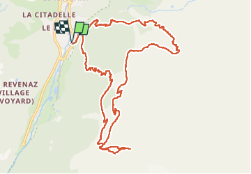

Length
13.9 km

Max alt
2114 m

Uphill gradient
1090 m
Km-Effort
28 km

Min alt
1164 m

Downhill gradient
1090 m
Boucle
Yes
Creation date :
2022-08-05 06:48:47.248
Updated on :
2022-08-21 05:46:35.344
5h33
Difficulty : Easy

FREE GPS app for hiking
 SityTrail
IGN / Geographical institutes
SityTrail Plus
The world is yours!
About
Trail Walking of 13.9 km to be discovered at Auvergne-Rhône-Alpes, Upper Savoy, Les Contamines-Montjoie. This trail is proposed by aris.
Positioning
Country:
France
Region :
Auvergne-Rhône-Alpes
Department/Province :
Upper Savoy
Municipality :
Les Contamines-Montjoie
Location:
Unknown
Start:(Dec)
Start:(UTM)
323472 ; 5075406 (32T) N.
Comments